

Not exactly a good replacement for surveying but satellite measurements I hear are pretty accurate.
Most americans will move onto a property and just plop down a house with the windows facing the road, throw in a few yard ornaments and spend the rest of their lives mowing the lawn. We're not about that. Moving into a property is creating a relationship with the property. It's taken a lot of time for the current ecosystem to evolve. Your best bet is to ease into the system, figure out how it works, then make just a few minor tweaks to to make it all work in your favor without upsetting the whole flow of things. First you need to get a feel for how the land is laid out. Then you have to figure how to slow down and use the water, from the time it hits the ground (or your roof) til it finally leaves the creek, so you don't have to rely on some government agency to pipe water into your house.
I hadn't outlined the other hills in the woods yet, but so far the highest elevation on the landscape was in the 1052'-1053' area up by the building area (far left), and the lowest was 994' where the creek let out onto the next lower property (the red area in the middle). So in 404' the property drops 59 feet'. This section will be the zone 0, zone 1 and zone 2 areas for gardening.
Below there's a satellite shot of the place with my notes. The green outline is all our land.
Building will likely be along the 1040'-1050' elevation lines, and the 1030', more closely lined area will be for terrace gardening. We're thinking it might work best to cut a drainage ditch along the northeast contour and drain it west where we can make a small fishpond along that only spot where it dips into the contour. We could incorporate that into the building as an aquaponics pool. Maybe if we find that it overflows we can build some trickling waterfalls along the west border until it empties into the first of the garden swales below the building area, like this...

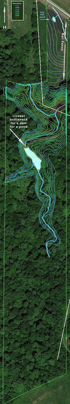
The south facing hill at the north end of the land will be the best place to capture the sun. The northern rail fence we plan to plant corn and sunflower, maybe Jerusalem artichokes, and lots of fruit trees. That, along with the backfill to the house and the downward slope of the hill, will protect us from the cold north winds in the winter time.
There's an existing rail fence all along the east side also that would be great for growing plants with vines and plants that need support. The fence is a few feet in from the eastern border of the land. The previous owners built it that way so they could mow around it. There'll be no talk of mowing on this property :-\ But since we have that unused space there, planting can be done along the other side of the fenceline to save room for more plants on this side, so the space won't go un-utilized. Maybe a series of arbors can also go along the east side of that fence for things like gourds, or we can grow grapes and other bush-type plants in that strip.
There's a small bottleneck farther upstream that so far appears to be the best place to build a dam for a woodland pond, but that's a huge undertaking, especially given that I doubt I can get equipment back there. It's something I'd have to build when we've moved in and probably not til we've paid off the land so I can take a few weeks off work. But it would be a place to grow water plants and bring in more biodiversity. With two streams dumping into that spot a few rainstorms might fill it up quickly. There may be a better spot farther upstream. When I finish drawing the contour lines I'll be able to tell better.
To the south of us is a pasture (lots of puffball mushrooms we've seen already) and west is a corn field. Since it's likely a Monsatan-fed and pesticide-sprayed field, the entire west side top swale(s) will likely need to feature some heavy myco-remediation (cleaning with mushrooms), probably in the form of strawbales in the swale-ditches and hugelkultur mounds on its downhill side, to limit the flow of pesticides into our stream.
Nut trees will likely be planted around the woods, but maybe not til we find out where all the yummy morels are growing. We don't want to disturb the existing edibles - that's already free food for zero work. We've already found a few thick patches of puffballs, some hickory, pawpaw, black raspberries, wild grape and a few other edibles. We'd like to try to propogate those wild edibles as much as we can, as well as importing some of the plants we have where we're living now, like Mayapple, black raspberry, violets and spring beauties, wild onion, chickory, sweet annie, sorrell, etc.
There are still more contour lines to draw and more observing to do before we make final decisions, but edible fruit/nut trees take a few years to mature enough to get food from them, so we can't afford to wait too long. Right now it's a priority.
No comments:
Post a Comment